Into Heaven...

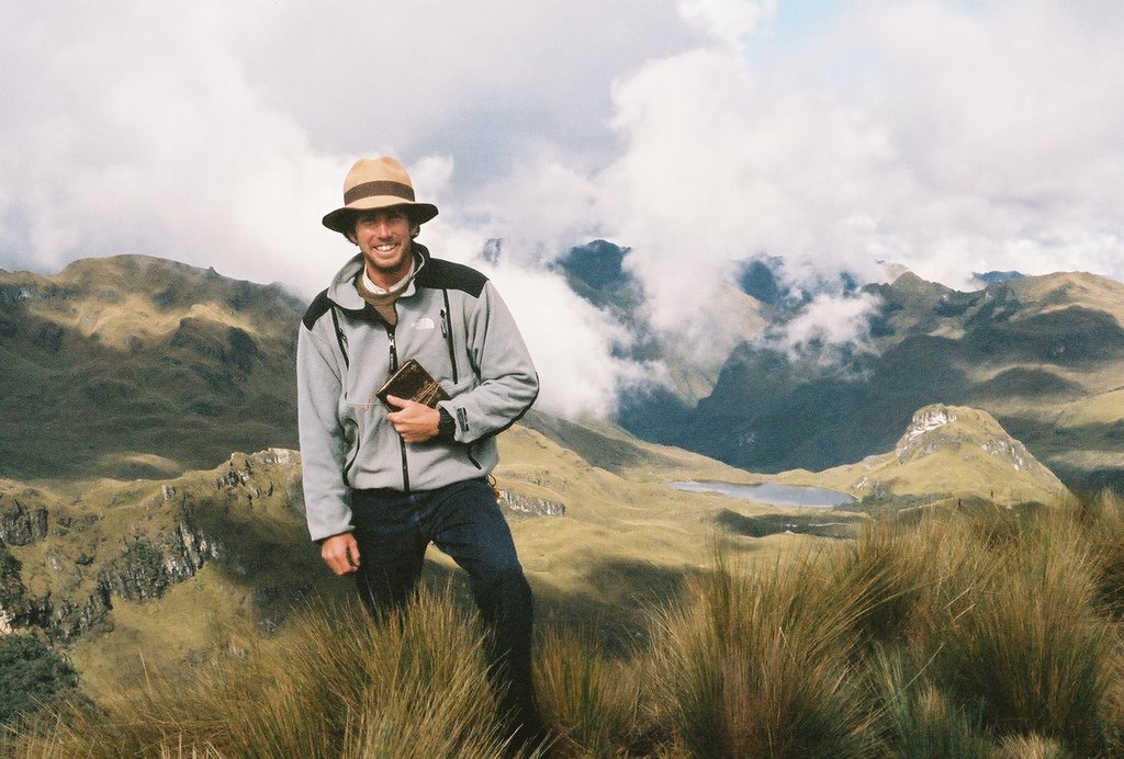
After eating and sleeping and eating some more and finally going to bed for the night. Neither of us slept very well, but we slept. At nine we got down stairs for desayuno, Nescafé con leché y coco, bread, and fresh juice. Ready for the day we made it to the bus station and were on our way to Cajas National Park for the day. Armed with sweaters, and backpacks full of cookies and water, we felt invincible, Especially since I was wearing my Panama Hat - no sun burn today! Jon even put shoes on.
The bus crawled up into the mountains and we were on our way back to Guyaquil - except we didn´t have any of our luggage. After entering the park, the bus pulled over and kicked us off. Less one dollar in our pocket we were on the side of the road looking across the lake Toreadora, situated just below the ranger station for the park. Excited to set foot into adventure in the Andes we took our time walking down to the station from the road, taking time to notice the lama peacefully and picturesquely sitting in the grass looking out across the lake, as if longing for something. I imagine greener grass.
I was pleased to meet the ranger and discover that he was just like any US park ranger, mellow, eager to give us his opinion of the way we should go, particular about getting our information and destination, and most importantly, collecting our ten bucks. That´s what we get for being out of state.
Newly equipped with a bird guide, park map, and little ticket that said ¨Paid,¨ we started off on the ranger selected route. Down the hill to the lake, half way around, and then out. Out past this hill and that peak, around all those lakes, DON´T GO RIGHT, and then hook back around to the road about 4 km to the west. From there we should be able to flag a bus back to the station and then back to Cuenca.
*an aside...
The state of Ecuadorian soil.
Depending on where you are it could feel sandy, solid, squishy, or soggy and slippery. The beach, Montañita and Mompiche offer the sandy, while Cuenca, Quito, Guyaquil, and Baños offer solid. Squishy, soggy, and slippery, all kind of meld together sometimes. Vilcabamba and Otavalo were a little slippery at times, and Tuminuma was a little squishy. But no place yet had the hybrid version of it all as did at Casas. ...

So down we went. With my Timberland's I was particular with where I stepped and Jon with his brand new Top Stars, the same. Because of the moisture in the hills, the ground was saturated to the brim. Where there was no vegetation there was trail, and where there was trail there was mud. So, we walked upon vegetation. Little guys, grasses and these funny plants that resembled sea enemies. I was so proud with every jump and tip toe, by the time we were halfway about the lake and ready to depart the very damp and hike through the slightly damp, my shoes were clean and purty. - you know there´s only one reason I mention this... okay, good, I´m glad we´re on the same page - around the first peak we went and into a Quenua (Cane-wah) ´forest.´ Now these Quenua are special for some reason or another, but for those of you playing the home game just imagine Mansanita bushes in the California hills, except bigger.. or you´re really small.. so you´re walking under all of them. Still clean, we walk down, under, through, and over these in tangled trees. Their red bark pealing as you traverse their monkey bar orientation. One hand hold out of every one is covered with lichen and moss and it oozes between your fingers leaving you feeling guilty for the heinous murder of some squishy animal - alas, I think, or hope, it was only plant life and not worms or larvae or baby chickens, I pray. Under your feet the Quenua play a different trick. The bark stripped and the wood bare, words like traction and sticky, standing and happy, are thrown out the window and thusly replaced with ¨Awe F$"K¨, and ¨Ho!y S*!T, here I go!!!,¨ and the ever present, ¨Agh!¨ and ¨Ouch.¨ With a grumble and a brief and gentle rub of the rump you continue along the trail. Not long after our forest slip and slide begun we became as you say - rained upon.
My hat drooped and my jeans and perfectly preserved shoes were wet. We hid under a rock and examined the map. Jon pulled out his fancy smanchy GPS - why didn´t the bus lords pluck that from the sky on our way to Quito? eh??.. anyway, we tried to rectify ourselves with the map. For the first time since we started along the very well marked trail we actually looked at the map. Now this map... I´m going to bring it home so y´all can have a purty look at it, doesn´t make any sense. Starting with the longitude on the left it then gives gridded numbers like 6-89, 6-90, 6-91.. etc.. all the way till 7-15, then it provides the other longitudinal coordinates, 79 degrees 7 min 18 seconds to 79 degrees 23 min 31 seconds.. there was no smashing 6-89 into those cords. Frustrated we folded the map up, shoved it into our back pockets and kept on keepin´ on. Jon with his idea where we were and I with mine. I´ll be the first to say, I was wrong. After loosing ourselves in the forest and then above the forest we took a break, attempted to decipher the map one more time and then, from a higher perspective found the trail and were back on track - except we didn´t know what trail we were on. The map was horrid. After sometime in the forest and then out onto a bluff overlooking another lake we determined where we were. Soaked and already starting to get tired and frustrated we opted to walk back toward the ranger station. - perhaps we´d give up for the day, with our ten dollars paying for an ankle mud bath, or perhaps we´d seek higher ground, ten going to the full cleanse of body and soul.
Back at the lake the rain was gone, our shoes were still wet, but they´d been that way for a while now and one hardly noticed. Looking left, across the lake, the ranger station, with it´s smug roof and fancy concrete paths mocked us, and even further past that the fancy highway that buses drove upon carrying smug dry passengers to their happy dry homes to eat their warm, well cooked meals, sleeping on their soft dry beds. Ooooh, Left - the emotion it evoked. Looking down one only saw their shoes, muddy, soaked, and behind the darkened leather cold toes wiggled just enough to move warm blood in and cold blood out. In front of that was the map, the map with lines intersecting and colors representing, the map that placed us some where within 30 km of someplace, there it was in our hands as we looked down. In front of us the trail back around the lake which ended us to the left, and behind us, well, trail we had just walked, muddy and covered in memories. That left right.

Now right didn´t seem so bad after justifying why all the other directions were so aweful, but as it turns out, perhaps we should have done better analysis. 365 meters later we´d be questioning our decision to take the high road. To our right a seemingly small peak, compared to the jagged peaks about us, promised a wonderful view of the park, local to us, as well as a challenge that we easily met. So we began, at approximately 3,900 meters. Unlike trails of the California Sierras, or the Colorado Rockies, or even that of Ecuador´s Volcanic trail up Tungururha, this one went up - straight. It was unfortunate we didn´t have the Chinese technology of thousands of stairs to climb. Instead, just muddy foot prints and clumps of tall grass - the same grass, as it was, which is used to weave the fine Panama Hats of Ecuador.
Our eager pace fell to fast and fast fell to consistent and consistent finally ended with sitting. The air seemed to lack a certain smog - or something I couldn´t quite put my finger on. Light headed and ready to vomit we sat, breathing heavily, and exchanging half words between every four breaths. Are we THAT out of shape? Thankful to have 625 mL of water a piece, as soon as we were confident we wouldn´t breath the water, we sipped in order to achieve semi-natural vital signs. Our next steps were slow and deliberate. Heavily planted feet guaranteed less slippage and slower pace allowed for less exhaustion though we still took breaks at every available rock out cropping. As it was, we were essentially climbing a rock face, thus there were frequent stops.
Finally we were at the top. We could see it, the post stuck into the tallest rock sitting atop the peak. 10 meters, 6 meters, 3 meters, defeated! We were defeated. Just as you took your seemingly ultimate step and looked up there it was, a higher point one more hill up from this one, taking a break to console each other we kept on truckin, after all we couldn´t stop there, not with the pain in our lungs and the burning of our legs. 10 meters, 6 meters, 3 meters, was this some kind of sick joke? If I had a nickle for ever time.... we kept on. By now the rain was long gone and had been replaced by a bitter wind. The kind of wind that asks for your hat, but takes your hands, your nose, your ears, and anything else that is cinched down tight enough. It kept my water cold, but my hands were ablaze just as much as my lungs. Jon was equally incapacitated. We rested under yet another rock. This one quite large and quite apt to squish. I´m glad it didn´t. From our safe house the wind was a little less bitter and the view was promptly moved from our footing to the spectacular horizon.
The Clouds had receded from where we were and hung about the taller peaks. The mountains seemed different from the others we´d seen in Ecuador. While the hills of Cuenca and Vilcambama slowly melted and withered with time, these seemed to grow larger. The rocky buds atop each crest, with enough water, sun, and time, would bloom into taller, more grandiose pillars of nature. Massive implications of mother Earth´s Dominance. Perhaps into Heaven they´d reach.. perhaps the one we were aboard was on it´s way right at this moment. I couldn´t feel it move - I suppose I was just impressed. Below the towering sides, forests of Quenua snaked their way up ravines and crags, weakness in the design of superiority or strength of symbiosis. Below the forests, a black opal mirror had been shattered and strewn about - dark and then spotted with color and magnificence rivaling that of the tallest peak. Each lagoon was connected by pieces of silver thread and as the sun peaked in and out of sight so did the river beds below. What a place to rest. Alas we must keep on, the view at the top - if such a place existed, would be magnitudes more spectacular.

The following peak was too a fraud, but finally we arrived. Making a full scan of the local horizon, we were indeed at the top of this seemingly unimpressive hill. 4,265 meters later we were pooped.
Jon pulled out his Pentax and did his best to take a full panorama of the place, I wrote a bit in my journal, and Jon fell asleep for a short bit with a handkerchief over his eyes because in the magnificence of it all. Blue patches of sky polkadoted above our heads and the sun had come out to play. The top´s purported spectacularity was indeed legit.
Time for decent. Not wishing to evoke memories of old we started down the other side of the hill - by the map, this was the lighter way. oooh, that map. At our first cliff we were curious, at our second, perplexed, the third we scaled. Finding ruts carved out by rain water and waterfalls we were able to wedge our selves down each seemingly preposterous trail head and onto the next with unimpressive falls and highly impressive tumbles in between. Tired and sore we wish we had in our possession cardboard and at times resorted to skiing across grass tops with prayers of cactus and cliff free landings. After our half hour decent we arrived back at the lake and the ranger station couldn´t look any better. Another fifteen min of carefree shoe placement landed Jon in the lake once, I with mud about my face and chest, and both of us within ten meters of the station. Stopping briefly to talk with a fellow, local Ecuadorian Biologist, about his beautiful country, our travels, and the awesomely taxing hike we had just returned from, we hoofed it up to the road to thumb the next passing bus.
The sun slowly disappeared and the wind began to prod. I tried reading to avoid thinking about it, but I knew I´d be cold soon enough. I could see my breath. The bus never even put on it´s brakes.
Our biologist friend with his daughter and wife and another couple pulled out of the drive and turned back toward Cuenca. They stopped and pointed in that direction. We spent no time at all trying to decipher language, we were in the 1990something Jeep with the door closed, warm.
All of them spoke very clear English and the words that one didn´t know another would. They were interesting people who loved their country, regulars at the park on weekends, the liked the Beatles and we listened to them the entire way back. The were good - genuine. The dropped us off closer than the bus would have and happy to have met new people and to be so close to a shower and dinner we were back at the hostel in a flash.
Tired and beat - we´re both satisfied with our decision to earn a good nights rest.
(Awesome photos by Jon)
posted by John-Man at 8:18 PM
![]()


0 Comments:
Post a Comment
<< Home